Generalizable deep learning
We build deep learning models that combine climate reanalysis, satellite imagery, and in-situ records to estimate river discharge, sediment flux, and lake ice where direct measurements are sparse.
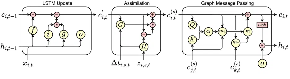
River observations are uneven in space and time. A small number of sites have daily gauge records, and satellites pass over at irregular intervals. We design deep learning models that learn from several of these sources together. One example combines daily climate reanalysis with Landsat water color to produce continuous daily estimates of suspended sediment concentration, sediment flux, and discharge.
Current work extends these models to assimilate sparse observations from multiple sources, including SWOT, as they become available. The models also pass information along the river network, so estimates at one reach draw on observations upstream and downstream. We focus on models that generalize to rivers outside the training data.
Related publications
Estimating Daily Suspended Sediment Flux from Multiple Data Sources using Deep Learning
Journal of Geophysical Research
Abstract
Suspended sediment concentration, flux, and river discharge are essential indicators of river ecosystem health and reflect watershed-scale processes. Monitoring these variables is labor-intensive, leading to sparse and geographically biased observations and the development of models to fill in the observational gaps. These models generally use either climatological data or satellite images to estimate one of these variables. In this work, we present a novel deep learning model that can leverage multiple data sources with different temporal characteristics to produce continuous daily estimates of suspended sediment concentration (SSC), suspended sediment flux (SSF), and discharge. The model first encodes daily hydrological data from the ERA5-Land reanalysis using a Long Short-Term Memory network and water color data from Landsat satellites using a Multi-Layer Perceptron network, then merges these encoded data sources using a cross-attention decoder. We train and test the model on a large dataset of in-situ observations from 630 river sites over 43 years in the contiguous United States, covering a wide range of watersheds and conditions. We produce SSC, SSF, and discharge predictions with respective relative errors of 54%, 73%, and 28%, and relative bias of -15%, -19%, and -3%. We use our model to create a dataset of continuous daily SSC, SSF, and discharge for all large rivers in the contiguous United States. This new model architecture provides a valuable tool for monitoring river systems, addressing limitations of single-source models and offering a framework applicable to other Earth systems monitoring problems where integrating diverse data streams may be useful.
Modeling Daily Ice Cover in Northern Hemisphere Lakes with a Long-Short Term Memory Neural Network
Geophysical Research Letters